
GeoRank
GeoRank compares places by sunshine, cost, tax, and visa rules, then lets AI analyze your shortlist for relocation decisions.
VisitPublished on:
July 13, 2026
Pricing:
About GeoRank
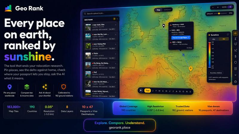
GeoRank is a free, no-signup interactive map tool that ends the chaos of relocation research. Instead of juggling a dozen open tabs across weather sites, Numbeo, embassy pages, and nomad forums, GeoRank layers 8 critical data sets over a global grid with ~5 km resolution. It is built for digital nomads, remote workers, expats, and anyone deciding where to relocate or spend an extended stay abroad. The tool lets you explore every place on earth ranked by metrics that matter: sunshine hours, temperature, rainfall, outdoor hours, tax rates, visa and residency routes, cost of living, geopolitical risk, and community-sourced Nomad Pulse sentiment. You can pin up to 20 candidate locations, save them across sessions, and switch to Compare mode to see every metric as a delta against your current home. An AI assistant reasons only over your own shortlist, giving cited, grounded answers to questions like "which of my 5 places has the best winter?" GeoRank replaces generic browsing with a real decision engine, making it the ultimate tool for choosing where to live next.
Features of GeoRank
9 Live Data Layers at Your Fingertips
Toggle any of 9 data layers on the interactive map, each powered by authoritative sources. Sunshine data comes from SARAH-3 satellite and ERA5, calibrated against 182 ground stations. Tax rates use OECD, PwC, and KPMG data. Visa and residency routes cover 47 destinations across 10 passports. Cost of living spans 478 cities. Geopolitical risk and Nomad Pulse sentiment add real-world context. Stack layers to see the full picture of any location at once.
Pin, Save, and Compare Against Home
Click any location on the map to pin it to your shortlist, with up to 20 places saved across browser sessions. Switch to Compare mode and set your current home as a baseline. Every metric transforms into a delta: how many more sunshine hours, how much cheaper, how much safer, or how differently taxed compared to where you are now. This relative view makes tradeoffs instantly visible, turning abstract data into personal decisions.
AI Assistant That Knows Your Shortlist
Chat with an AI that operates exclusively on your pinned locations, not a generic knowledge base. Ask "which of my 5 places has the best winter?" and it reasons across all your specific data in one response. The AI provides cited answers with sources, showing exactly which metrics support its conclusion. This feature eliminates manual cross-referencing and gives you grounded, personalized insights in seconds.
Calibrated Against Ground Truth, Not Raw Satellite Data
GeoRank does not use raw reanalysis data that overestimates sunshine in cloudy regions. It merges SARAH-3 satellite observations with ERA5, bias-corrected against 182 ground stations from Reykjavik to Phoenix to Sydney, with orographic terrain corrections. This calibration delivers ±8% accuracy in most locations, with clear methodology for high-altitude and coastal microclimates. You get reliable data, not misleading estimates.
Use Cases of GeoRank
Finding Your Ideal Winter Base
A digital nomad on a UK passport wants to escape cold winters. They pin 5 candidate locations, set their home city as baseline, and ask the AI "which of my pinned places is best for a winter base?" The AI compares sunshine hours, temperature, outdoor days, and visa duration across all locations, citing specific data from SARAH-3 and passport rules. Within seconds, they know exactly which place offers the warmest, sunniest winter with the longest allowed stay.
Comparing Cost of Living and Tax for Relocation
A freelancer considering Tbilisi and Paphos uses the map to pin both cities. They set their current home as baseline and switch to Compare mode. The delta shows Tbilisi is $700/month cheaper but has 1,153 fewer sunshine hours. Tax rates show both offer 0% on foreign-sourced income. The AI confirms Paphos meets their sunshine threshold while Tbilisi does not. This single session replaces hours of manual research across multiple websites.
Evaluating Family-Friendly Destinations
A family with children uses GeoRank to find a safe, affordable, and sunny location with good residency options. They pin 8 candidate places across Europe and Asia. Geopolitical risk layers show stability levels. Cost of living data reveals monthly expenses. Visa layers show family residency routes. The AI answers "what are the tradeoffs between Paphos and Tbilisi for a family?" with comparisons on safety, cost, and sunshine, helping them narrow choices quickly.
Researching Tax-Friendly Destinations for Crypto Investors
A crypto investor uses GeoRank to find locations with favorable capital gains tax treatment. They explore the map ranked by crypto CGT, toggle the tax layer to see OECD and PwC data, and pin countries with low or zero rates. Compare mode shows the delta against their high-tax home country. The AI explains which pinned places offer the best tax structure for crypto holdings, with cited sources from official tax databases.
Frequently Asked Questions
What data sources does GeoRank use and how accurate are they?
GeoRank uses SARAH-3 satellite observations and ERA5 reanalysis for sunshine and temperature, bias-corrected against 182 ground stations worldwide. Tax data comes from OECD, PwC, and KPMG databases. Cost of living covers 478 cities with regularly updated figures. Visa and residency data covers 47 destinations across 10 passports. Accuracy is ±8% for most locations, with high-altitude areas at ±15% and coastal microclimates at ±20%. All sources and methodology are documented on the site.
Is GeoRank really free and do I need to sign up?
Yes, GeoRank is completely free and requires no signup, no email, and no account creation. You can immediately open the interactive map, toggle data layers, pin locations, and use all features including the AI assistant. Pinned locations are saved across sessions using your browser storage, so your shortlist persists without any login.
How does the AI assistant work and what can I ask it?
The AI assistant operates exclusively on your pinned locations and their specific data. It does not access a generic knowledge base or the internet. You can ask questions like "which of my 5 places has the best winter?" or "score my shortlist: sunshine, cost, and low tax combined." The AI reasons across all metrics for all your pinned places in one response, providing cited answers with source references. This ensures answers are grounded in your personal data, not general information.
Can I use GeoRank on mobile devices?
GeoRank is built as a responsive interactive map that works on desktop and mobile browsers. The map supports panning, zooming, and tapping to pin locations on touchscreens. Compare mode and the AI chat interface adapt to smaller screens for easy use on phones and tablets. No app download is required since it runs entirely in your browser.
Similar to GeoRank

Wheel of Names Picker AI
Wheel of Names Spin Wheel Picker tool for classrooms or events


EmoScan
#1 Emotion Intelligence Analysis tool to understand better Texts, Email Letters, Videos, Photos and even Dating profiles

wery.ai
Wery is an AI-powered virtual creative studio for entertainment content.

Snapkin
Snapkin is a calorie tracker you use by photographing your plate.

Verla AI
Verla is an AI academic assistant for university and college students, combining AI essay writing, academic research, AI detection, AI humanization

AI Face Swap Video
Swap any face into any video online with AI in minutes. Upload a clip and a photo, get natural lighting and expressions. Free credits on sign-up.

AIPetGen
AIPetGen turns a photo of your dog, cat, or other pet, or a written description, into a new picture or a short animation.